In January, after a break in the rain in the Bay Area, we made a little getaway to warmer weather in Central California. Although visiting the coast and the Sierra Nevada Mountains in a single trip seems like a lot of ground to cover, our weekend turned out to be pretty relaxing and filled with easy walks leading to beautiful natural vistas (not to mention some pretty decent food!). Plus, we got to visit not one but TWO spectacular rock formations named Morro (and Moro) Rock on this trip :).
If you don’t mind a fair bit of driving through some beautiful scenery, this trip is doable in two days.
Weekend Itinerary Saturday (7.5 hours of driving, short walks)- Drive to San Luis Obispo for lunch at the sun-filled Vegetable Butcher. (3-4 hours from the Bay Area). If you get an early start, get a glimpse of rolling hills of vineyards at DAOU in Paso Robles on your way.
- Stroll along the Bluff Trail at Montana de Oro State Park (30 minute drive), and then enjoy a dramatic beach near Morro Rock (another 30 minute drive).
- Back in San Luis Obispo (20 minute drive), relax with a milkshake at Scout Coffee, stroll around downtown, and grab some doughnuts for the road at SLODoCo.
- Stay the night in Fresno, Visalia, or Tulare (2.5-3 hours of driving). If you like authentic Neapolitan pizza, check out Pizanos in Visalia for dinner.
- Get an early start on the trail to Moro Rock in Sequoia National Park. (~2 hour drive, 1.5 hour hike).
- Stand in awe under giant sequoias, including General Sherman – the largest tree on Earth – and General Grant – the nation’s Christmas tree (1 hour drive, short walks). Along the way, you’ll drive through spectacular scenery along the General’s Highway connecting Sequoia and Kings Canyon National Parks. Note – the road between the parks can close in winter.
- Head home (4 hour drive). Eat in Fresno or Gilroy if you get hungry along the way.
While most of the walks on this trip are easy, hiking boots are a good idea because some of the trails can be slippery in the winter. Sunscreen is also a must, as you’ll hopefully be seeing a lot of sun on this trip!
San Luis Obispo CountyIt’s pretty much a straight shot down highway 101 to reach San Luis Obispo, often called the happiest city in America. If you had beautiful vineyards and gorgeous oceanfront within a short drive of your town, you’d probably be pretty happy, too.
Before you even get to San Luis Obispo proper, a stop in Paso Robles is well worth it. While we weren’t able to squeeze it in on this trip, the rolling vineyards at DAOU are gorgeous, as is the hilltop tasting room adorned with fountains and gardens. Be prepared to spend a little time here, as you need to take a shuttle from the parking area to the top.
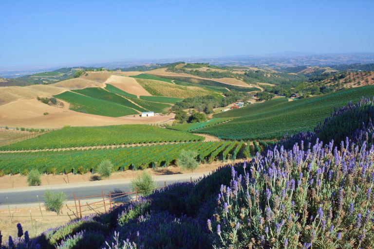 A summer view at Daou Vineyards. The wine country is also very pretty in the winter.
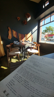
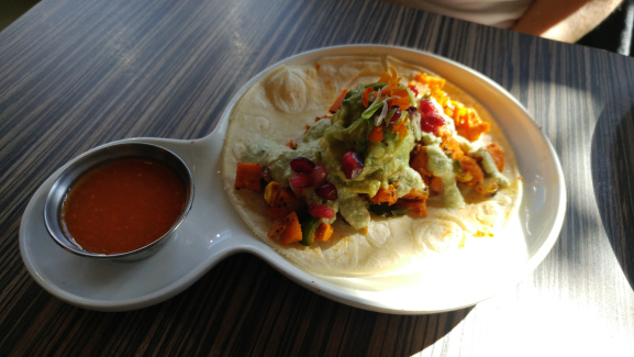
In San Luis Obispo, we had a great lunch at Vegetable Butcher. With options for both vegetarians and omnivores alike, the focus is on using fresh ingredients to create colorful, flavorful dishes. The mole sauce on the enchilada and the curried sweet potato taco that we tried were both very appealing, as was the orange salsa that came as a side dish. The entire restaurant is decorated with warm wood tones, and the seats by the window were especially nice in the sunlight.
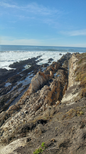
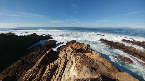
After lunch, we continued onward to the coast at Montana de Oro State Park. On this trip, we were trying to take it easy, so we took in the scenery along the Bluff Trail, but you could do a more challenging hike at Hazard Peak or elsewhere in the park if you felt so moved. For the Bluff Trail, we parked along the road just past the campground, but you could also park all the way at the south end of the park to reach the far end of the trail. The park is free to enter, and the parking lots fill up quickly, so be patient and don’t worry if you have to walk a little bit! The trails connect to the road at many points.
Along the Bluff Trail, there is access to beaches, tide pools, and plenty of interesting rock formations.
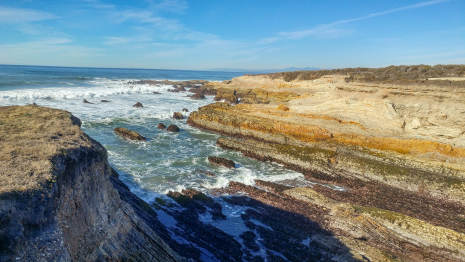
From the trail, looking northward, you’ll also see the looming figure of Morro Rock. Morro Rock is one of the “Nine Sisters,” a set of volcanic plugs created long ago when magma welled up inside of rock formations and solidified there, creating distinctive mounds along California’s Central Coast.
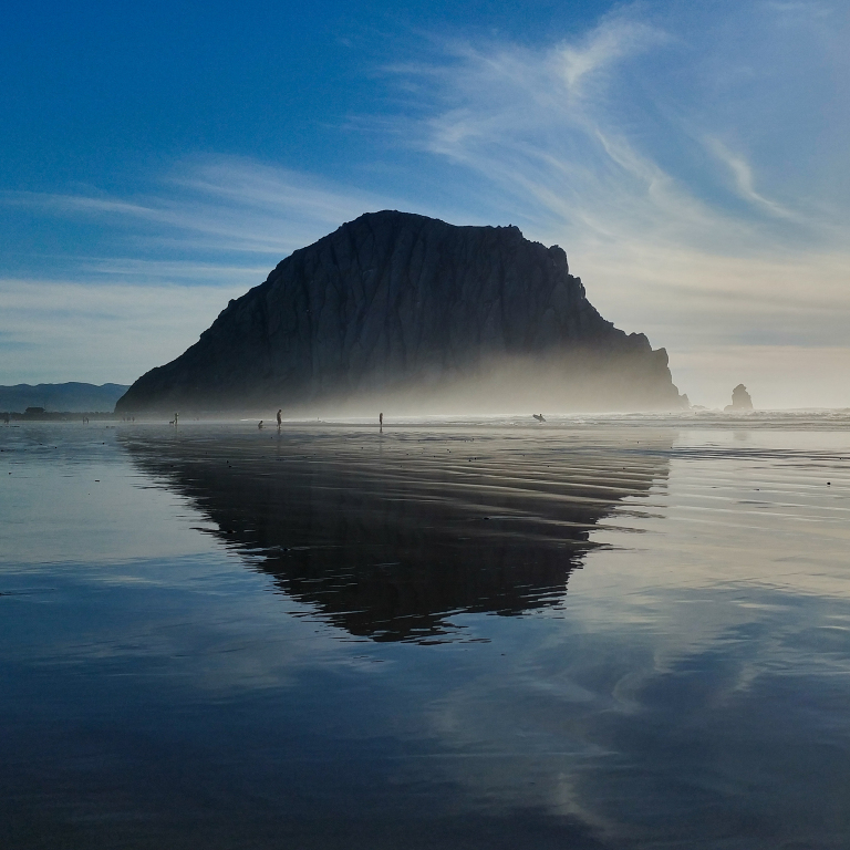
We were keen to see the rock up close on this trip, so after our walk at Montana de Oro, we drove up the coast to Cloisters Community Park in Morro Bay (it’s free to park there, and there is a public bathroom, but you need to provide your own soap). We followed a trail past some sandy dunes to the beach, where we again saw the rock in the distance. Once we reached the beach, we walked towards the rock (it’s about 1.5 miles each way from the park to the rock). In the afternoon, there was an amazing fog right near the water, giving the rock a very dramatic appearance. In addition, the sand on the beach is dense, so when it is a bit wet, it reflects the rock beautifully like a deep pool of water.
With most of our walking out of the way, we headed back into San Luis Obispo to grab a snack before hitting the road for the mountains. One of our favorite stops downtown is Scout Coffee, a hip shop that serves delicious milkshakes made with Santa Barbara’s famous McConnell’s Ice Cream.
 Milk shakes at Scout Coffee Co.
While in SLO, you can also stroll around downtown to check out the mission, the famous bubblegum alley, as well as the shops in the downtown core.
 Bubblegum alley.
On the drive out of town, we also made a stop at SLO Donut Company (SLODoCo): their buttermilk doughnut was top-notch (crispy and sweet outside, and soft and melt-in-the-mouth inside) and the vegan maple doughnut had an interesting hearty, nutty taste. To get to the mountains, we retraced our steps on highway 101 to Paso Robles, and then drove Northeast along another set of highways. Even though we were driving at night, the road was not super windy, but there was a dense fog in places during our drive.
We decided to spend the night in the Visalia area, which is the largest gateway town closest to the entrance of Sequoia National Park. It touts itself as a small town with a great foodie scene, as voted by Rand McNally readers in 2012. Even though the town has over 100,000 residents, we were shocked to find many spots downtown empty on Saturday night… It worked out to our advantage, though, as we had next to no wait for some delicious Neapolitan pizza at Pizanos in the heart of downtown. The margherita has a great tomato sauce, and the carbonara (without the meat) had an excellent basil cream base. Both pizzas had perfectly charred crusts and very nice cheese.

After dinner, we spent the night at the Hampton Inn in Tulare, about 15 minutes further south. This Hampton Inn was newly renovated and located conveniently near the highway, a Wal-Mart, several gas stations, grocery stores, and an Outlet Mall. We also saved some money using the AAA discount and by taking advantage of an American Express Offer. In retrospect, we may have opted to stay in Fresno instead, as not too many restaurants are open on Sundays in Visalia, and the drive back to the Bay Area is a bit shorter from Fresno.
Sequoia and Kings Canyon National ParksWe got lucky with the weather this year. The snow in the Sierras is getting a late start, so many of the low-elevation trails in Sequoia and Kings Canyon National Parks were still open when we visited, as was the road connecting the parks. In these types of conditions, you can see quite a bit in a single day in the late fall or winter, leaving hikes in the Mineral King and Cedar Grove area to be tackled when the roads open back up in the spring. We used the NPS forecasts and webcams to get a better idea of conditions in the park.
We left our hotel around 8AM and made our way to the Giant Forest Museum in Sequoia National Park, passing through the entrance gate along Highway 198. We used our National Park Pass to waive the entry fee. We were a little worried because Visalia was still completely enshrouded in fog in the morning, but once we started to climb into the mountains, this totally evaporated.
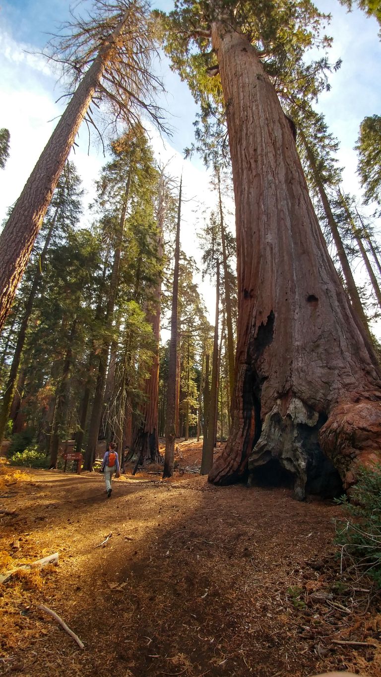
We heard that the weather in Sequoia National Park gets hazier throughout the day, so we started off our day by visiting Moro Rock (yes, another one!), a granite dome outfitted with about 400 stairs to an amazing view of the foothills and mountains of the Sierra Nevada range. In the summer, you can drive right up to the base of the rock, but that road is closed in the winter, so you have to hike from the Giant Forest Museum (about 1.7 miles each way). When we visited, the trail to Moro Rock was clear of snow, a beautiful soft trail under giant sequoias and other evergreen trees. We actually liked this trail better in some ways than the trails to the major trees in the park; on this trail it felt more like you were viewing the trees in their natural environment as opposed to being surrounded by boardwalks and fences.
From the base of Moro Rock, it’s about 400 stairs to the top. It took us about 10 minutes to get up there. We wouldn’t have done this hike if the rock was at all slick, but it had been dry for a few days, so the granite was easy to scale. It’s also hard to cross people on the stairs, so getting out early before the crowds made their way out here also helped us avoid delays on the way up.
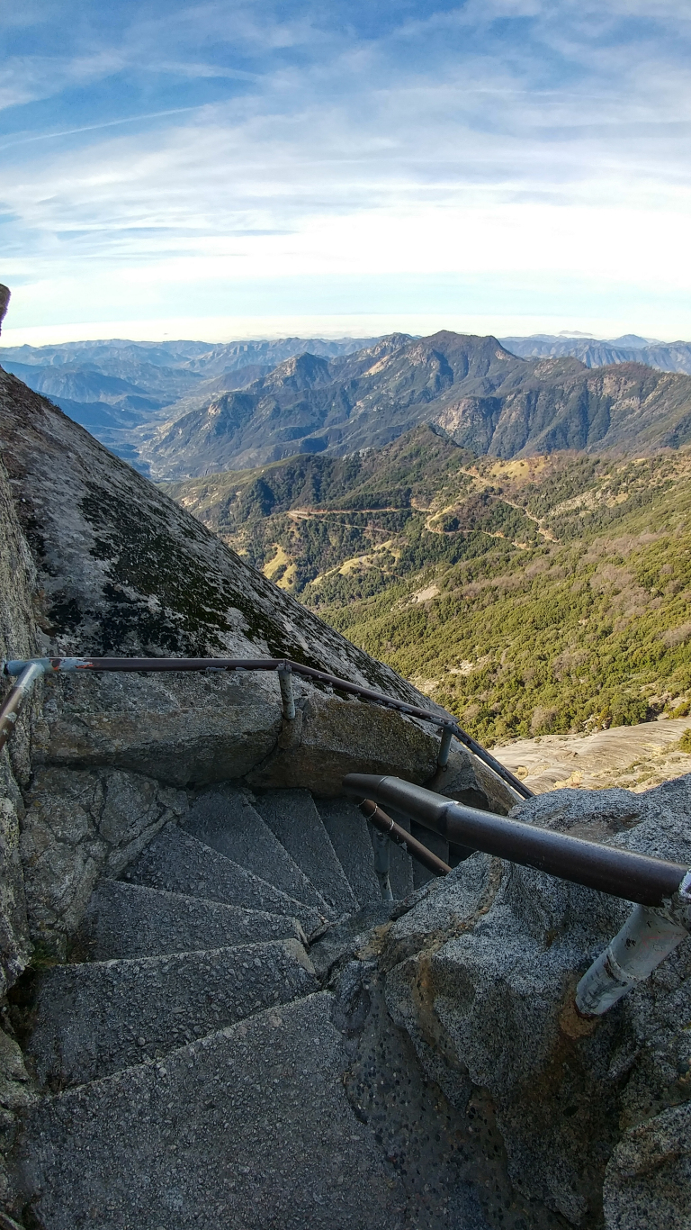
All along the way, you get great views of the snow-capped mountains to the west and the green foothills to the east, but the views at the top are just incredible.

One we returned to the Giant Forest Museum, we hopped in the car and drove to the General Sherman Tree, about 6 minutes down the road. Note that the summer parking lot, which is on the turnoff to Wolverton, is not accessible in the winter, so you have to park near the very small not at the trail head or along the General’s Highway near the tree. Because of the limited parking, it was a little difficult to find a spot, so take one as soon as your find one. The Sherman Tree is very impressive, and is worth seeing both from its base and from the overlook. The treetop branches themselves look like massive trees, and the base of the tree is close to 12 meters in diameter!
After visiting the Sherman Tree, we looped along the Generals Highway to Kings Canyon National Park to see Grant’s Grove. The density of absolutely enormous sequoias here actually seemed higher than in the Giant Forest, and there were some beautiful examples of trees in this part of the park (including General Grant) that had fire scars or full-out breaks in the trunk but continued to grow and thrive.

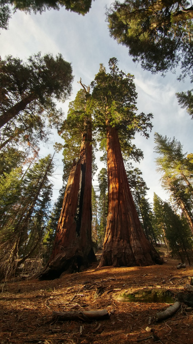
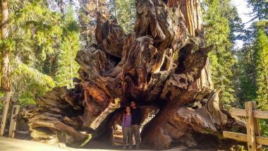
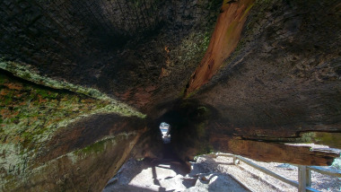
In Grant’s Grove, we also got to explore the length of a hollow fallen tree, from its roots through its trunk, which gave us a sense of how enormous it was when it was standing.
After checking out the grove, we made our way out of the park along highway 180, getting some spectacular views of the hills and valleys below the park as the sun began to sit lower in the sky.

A fog was starting to roll in over the valley again, giving rise to a very dramatic scene.

By this time, it was about 4:30PM, and so we could have driven straight back to the Bay Area in time for dinner. Instead, we spent one more night in Tulare (and had some decent Indian food at Cafe India Cuisine in downtown Visalia). The drive back up to the Bay Area the next day was super easy along major highways and through the picturesque Pacheco Pass, a great way to end our little getaway.
We’d love to hear some of your suggestions for activities in the Central Coast or the National Parks! Let us know your thoughts in the comments below.